 About a year ago I moved to Alameda, California. I was surprised to learn that Alameda is the only city in California that actually bans the construction of new apartments in its charter (which is like a city’s constitution) thanks to a ballot initiative, Measure A, passed by a citywide vote back in 1973. This November voters are going to have the opportunity to repeal the ban with Measure Z. Given the enormous problem of housing affordability in California and the Bay Area in particular I think this is long overdue and I’ve volunteered to work with the folks supporting measure Z: Yes on Alameda Measure Z.
Mapping Oakland’s license plate reader data
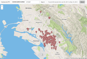
For the past few years the Oakland police department has been using license plate reader (LPR) technology to record the license plates of cars. In response to a public records requests the city released the entire data set to Ars Technica and later posted 13 of the original 20 files to their open data portal.
The released LPR data may be searched and mapped at this site, oaklandlpr.com. The site uses Flask and is backed by a MySQL database containing 2,738,523 LPR records. A sample search for a license plate belonging to an Oakland Police patrol car turns up 240 records.
UPDATE: I had to retire this website so the links no longer work. I used it as an opportunity to experiment with AWS, and once the trial period ended I couldn’t justify the expense of hosting it.
RunParticles ported to Windows
![]() I’ve ported RunParticles, my app for animating GPS track logs, to Windows. The installer is available here. It has been tested on Windows 8.1.
I’ve ported RunParticles, my app for animating GPS track logs, to Windows. The installer is available here. It has been tested on Windows 8.1.
Introducing RunParticles
RunParticles is a free, open source Mac application that animates many GPS track logs on a scrollable map.
Getting tracklogs into Mapnik
The following describes my experience generating an OpenLayers slippy map from GPS tracklogs using TileMill, TileCache, and Mapnik.
I started by exporting my run data from Garmin Training Center and converting it from Garmin Training Center format (.tcx) to GPS Exchange format (.gpx) using GPSBabel.
The resulting GPX had some improperly long, straight segments caused when I would stop and start the tracklog after taking BART underneath the Bay. I massaged the data a bit using a python script to weed out these long segments.
Run map + OpenStreetMap
Running map
Three years of GPS track logs made into a slippy map.
This little project was a lot more difficult than I thought it would be. It took a great deal of trial and error. I’ll follow up with a post on how I got it to work.
Garmin Connect Google Maps Greasemonkey script updated
I updated my Greasemonkey script that replaces the Bing Map with a Google Map in Garmin Connect. This version is made faster by completely disabling the Bing Map and it no longer fetches the map information twice. Additionally, I’ve fixed the lap display markers and improved the quality of the track line.
Install Garmin Connect Google Maps Greasemonkey Script v0.2.
I have also posted Garmin Connect Google Maps at userscripts.org.
Note: For some reason I had to uninstall the old script before installing the new one–Greasemonkey didn’t seem to recognize the upgrade.
Missing Google Maps on Garmin Connect
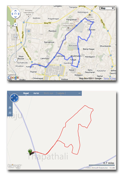
![]() Garmin Connect, a site I use to log my runs and bike rides, switched from Google Maps to Bing Maps back in November. Bing Maps’ coverage seems generally inferior to Google Maps and I think the maps just look better on Google. Also, Bing Maps seems to apply some overly-aggressive line smoothing, making tight corners look like wide curves.
Garmin Connect, a site I use to log my runs and bike rides, switched from Google Maps to Bing Maps back in November. Bing Maps’ coverage seems generally inferior to Google Maps and I think the maps just look better on Google. Also, Bing Maps seems to apply some overly-aggressive line smoothing, making tight corners look like wide curves.
I finally got around to writing a Greasemonkey script to restore the Google Map on the dashboard and activity pages.
Here’s the link to the script:
Install Garmin Connect Google Maps Greasemonkey script.

NWSClient 1.2 Released
 NWSClient version 1.2 is now available for download. This version fixes a number of bugs, adds detailed hourly forecast data, and increases the size of the text in the app icon so that the temperature is more readable.


